Coordinates: 55°51′45″N 4°01′36″W / 55.8625°N 4.0266°W
| Coatbridge | |
| Template:Lang-gd | |
| Template:Lang-sco | |
| File:Coatbridge coat arms.jpg Coatbridge coat of arms |
|
[[file:Template:Location map Scotland North Lanarkshire|240px|Coatbridge is located in Template:Location map Scotland North Lanarkshire]]<div style="position: absolute; z-index: 2; top: Expression error: Unrecognized punctuation character "[".%; left: Expression error: Unrecognized punctuation character "[".%; height: 0; width: 0; margin: 0; padding: 0;"> [[File:Template:Location map Scotland North Lanarkshire|6x6px|Coatbridge|link=|alt=]] Coatbridge | |
| Area | Template:Infobox UK place/area |
|---|---|
| Population | 41,170 (2001 Census) |
| - Density | 6,038 /sq mi (2,331 /km2) |
| OS grid reference | NS730651 |
| - Edinburgh | 33 mi (53 km) ENE |
| - London | 341 mi (549 km) SSE |
| Council area | North Lanarkshire |
| Lieutenancy area | Lanarkshire |
| Country | Scotland |
| Sovereign state | United Kingdom |
| Post town | COATBRIDGE |
| Postcode district | ML5 |
| Dialling code | 01236 |
| Police | Strathclyde |
| Fire | Strathclyde |
| Ambulance | Scottish |
| EU Parliament | Scotland |
| UK Parliament | Coatbridge, Chryston and Bellshill |
| Scottish Parliament | Coatbridge and Chryston |
| List of places: UK • Scotland • | |
Coatbridge (Template:Lang-sco, Template:Lang-gd) is a town in North Lanarkshire, Scotland, about 10 miles (16 km) east of Glasgow city centre, set in the central Lowlands. The town, with neighbouring Airdrie, is part of the Greater Glasgow urban area. It was awarded the trophy for the Best Small City in Scotland in September 2009 in the Beautiful Scotland environmental and horticultural competition. The first settlement of the area stretches back to the Stone Age era. Foundations of the town can be traced back to the 12th century when the area was gifted by Royal Charter to the Monks of Newbattle Abbey by Malcolm IV. It was during the last years of the 18th century that the area developed from a loose collection of hamlets into the town of Coatbridge. The town's development and growth has been intimately connected with the technological advances of the industrial revolution, and in particular with the hot blast process. Coatbridge was a major Scottish centre for iron works and coal mining during the 19th century and in this period Coatbridge was described as “the industrial heartland of Scotland” and the "Iron Burgh". Coatbridge also had a notorious reputation for air pollution and the worst excesses of industry. By the time of the 1920s however coal seams were exhausted and the iron industry in Coatbridge was in rapid terminal decline. After the Great Depression the Gartsherrie ironwork was the last remaining iron works in the town.
More info[]

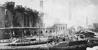
Summerlee blast furnaces in start of the 20th century Coatbridge. The present day Summerlee Heritage Park is sited here.
See also[]
Template:Coatbridge Template:Scotland topics
References[]
- ↑ The Online Scots Dictionary
- ↑ Scottish Place Names in Scots Scots Language Centre
Further reading[]
- Dillon, Des (2007) Monks, Luath Press Ltd
- Drummond, Peter and James Smith (1982) Coatbridge: Three Centuries of Change, Monkland Library Services
- Drummond, Peter (1985) The Population of Monklands in the 1980s, Monkland Library Services Dept
- Miller, Andrew (1864) The Rise of Coatbridge and the Surrounding Neighbourhood, Glasgow
- Miller, Thomas Roland (1958) The Monkland Tradition, Thomas Nelson and Sons
- Moir, Helen (2001) Coatbridge (Images of Scotland), The History Press; ISBN 0-7524-2132-8
- Van Helden, Oliver (2000) Old Coatbridge, Stenlake Publishing
External links[]
| Find more about Coatbridge on Wikipedia's sister projects: | |
| Definitions from Wiktionary | |
| Images and media from Commons | |
| Learning resources from Wikiversity | |
| News stories from Wikinews | |
| Quotations from Wikiquote | |
| Source texts from Wikisource | |
| Textbooks from Wikibooks | |
- North Lanarkshire Council
- Coatbridge Museum
- Out of The Darkness Evening Times, 27 October 2008 - Article on Coatbridge's industrial past
| |||||||||||||
| This page uses some content from Wikipedia. The original article was at Coatbridge. The list of authors can be seen in the page history. As with Tractor & Construction Plant Wiki, the text of Wikipedia is available under the Creative Commons by Attribution License and/or GNU Free Documentation License. Please check page history for when the original article was copied to Wikia |
